
Why This Partnership Matters
In today's competitive real estate market, standing out is everything. Buyers expect more than just basic information and a few photos – they want to understand a property's full context and visualize its potential. Our partnership addresses this need by integrating:
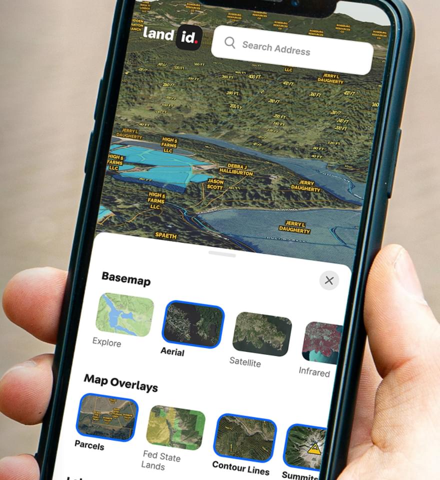
High-Quality Visuals: Listivo's professional media services connect directly with Land id's Showcase Maps, weaving land intelligence into visually stunning property presentations. This integration helps buyers see not just what a property looks like, but understand its unique features in context.
Immersive Storytelling: When maps and professional media services work together, they create a narrative that's far more powerful than either element alone. Buyers can explore property boundaries, understand topography, and experience high-resolution images and video of key features – all within a single, intuitive interface.
Streamlined Marketing Workflow: Real estate professionals can now request the combined compelling marketing assets from Listivo. The integrated solution reduces time and effort while delivering superior results – freeing agent’s time to focus on selling and prospecting.
A Foundation for Future Innovation: This partnership is just the beginning of an industry-wide initiative to integrate complementary real estate technologies into Land id's flexible platform. We're building an ecosystem that will continue to evolve with your needs.
How It Works in Practice
Imagine you're listing a unique property with distinctive features that don't align with the standard property listing options. With the Land id-Listivo offering, you can:
- Create can request an interactive Showcase Map highlighting property boundaries, topography, and key features
- Incorporate Listivo's visual media expertise directly into the map interface
- Add geotagged photos that show specific viewpoints and features
- Share a single, comprehensive presentation that gives buyers both the big picture and important details
- Track engagement to understand which property features generate the most interest
The result? A listing that helps qualify serious buyers, stands out, engages potential buyers more deeply, and communicates unique property value more effectively.
What's Next
The combined solution is available now. Real estate professionals looking to elevate their listings can explore the new partner-enhanced Showcase Map features by visiting id.land or listivo.com.
We believe that when you combine powerful data with beautiful visuals, incredible things happen. And this is just the beginning! Stay tuned for more innovations as we continue to expand the Land id Partner Program.
Ready to transform your property listings? Contact us today to learn how you can be among the first to leverage this powerful new integration.
For more information on the Land id Partner Program visit https://support.id.land/partners
Continue Reading
7 Real Estate Social Media Ideas For The Modern Agent
By Land id
Between Facebook, Instagram, LinkedIn, Twitter, and TikTok, social media isn’t going anywhere, which is good news for real estate agents. 44% of realtors stated that they gained a new client in 2020 due to posting on social media, so if you aren’t on these platforms already, there’s no time like the present to join. The question is: Where do you start? What do you post? Below, we’ll walk you through 7 of our favorite real estate social media ideas to inspire your thinking.

Taking Out the Trash With GIS
By Land id
The versatility of GIS cannot be understated. It has been used to map planets, underwater continents, tree density, murder hornets, and now…garbage? Ocean microplastics, to be exact.


Explore Private Parcel Data & Property Boundaries
Download the Land id app and try for free.
